Insight from Henry W. Coe State Park
By Bruce and Joan Hamilton
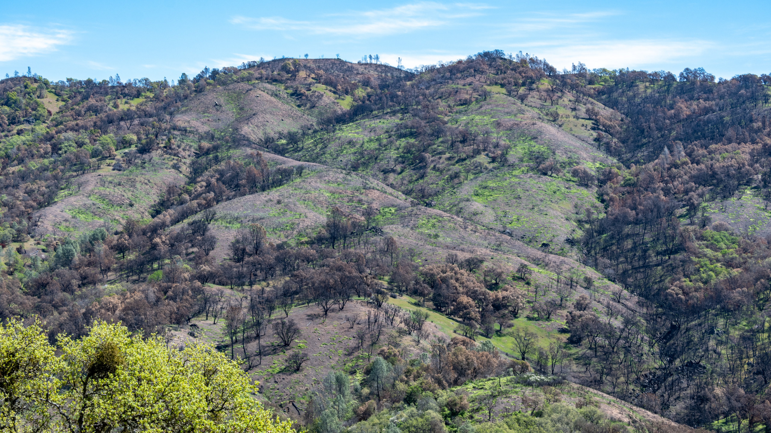
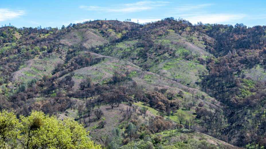
Henry W. Coe State Park. All photos by Bruce & Joan Hamilton
During the 2020 wildfire season in California, it felt like the whole world was on fire. When the smoke settled, 4.2 million acres had burned, leading to 28 deaths and the loss of more than 9,000 buildings. Stories appeared about how this might well be a catastrophic new normal.
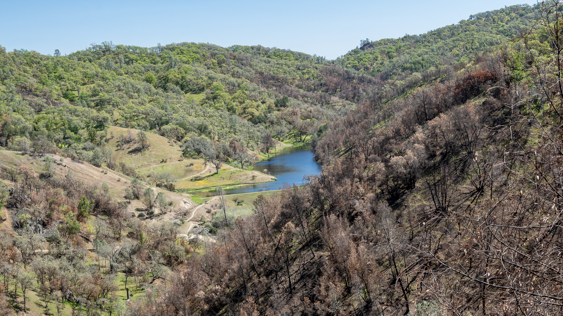
By fall, though, a different narrative started to appear. In the Santa Clara Unit (SCU) Lightning Complex, the fourth largest fire in the state’s history, no deaths and far less property damage occurred. Flames had hopscotched across the mostly uninhabited Diablo Range with varying intensities, while leaving some areas completely untouched.
State-park resource manager Wes Gray described Henry W. Coe State Park, in the center of the range, as “built to burn” and the fires within it as “natural and ecologically beneficial.”
So in hindsight were the 2020 fires terrible or beneficial? Were they something to be fought or welcomed? The answers vary across the state, but experiences at Henry W. Coe State Park suggest some underreported positive sides to the story.
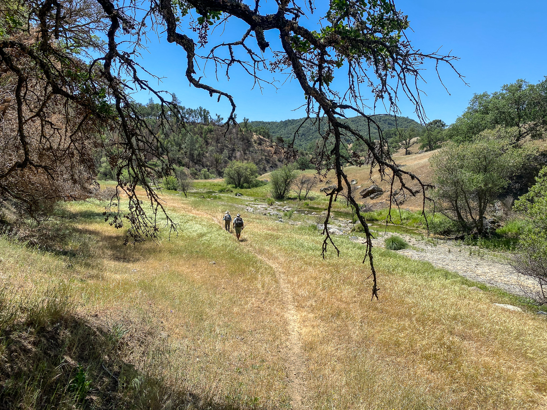
Hikers walking along Coyote Creek Narrows in Henry Coe
Only a 35-mile drive from San Jose, Henry W. Coe State Park is a little-known swath of old California, stretching south to Pacheco Pass with high ridges, steep canyons, deep lakes, and few visitors. At 87,000 acres, it’s huge—four and a half times the size of Mount Diablo State Park to the north.
Most of the land around it is privately owned, so it offers a rare opportunity to get out and stretch your legs in the central part of the 150-mile-long Diablo Range.
The western side of Coe has a drive-in campground, lush fields of wildflowers, and stately ponderosa pines. The eastern side is drier, more remote, and exhilaratingly open, with backcountry camping and head-spinning views from the outer Coast Range to the Central Valley.
The trails are strenuous, with lots of steep ups and downs. One section is called “the roller coaster.” As experienced hikers half-seriously warn newcomers, you train in the Sierra Nevada for Coe, not vice versa.
When the SCU fire approached Coe’s headquarters in August of 2020, the house of Coe park ranger John Verhoeven was in its path. “We were enjoying our smoke-filled summer,” joked Verhoeven, “when I noticed a nearby fire progressing rapidly.” He evacuated his family from their park residence and “accepted the high probability of losing the buildings up at headquarters.”

As the SCU Fire swept through Coe, it burned certain patches of the park, but left other parts untouched.
Verhoeven felt differently about the fire as he, Gray, and state-park district superintendent Eddie Guaracha drove a group from Save Mount Diablo through the backcountry eight months later. Verhoeven’s home in the park had been spared.
Almost all the other park buildings and even the park’s backcountry outhouses were still standing. “It’s really astonishing,” Verhoeven said, “with just two to three feet of mineral soil around a fire-resistant structure,” the fire backed off. Despite its size, the fire was not so all-consuming as it first appeared.
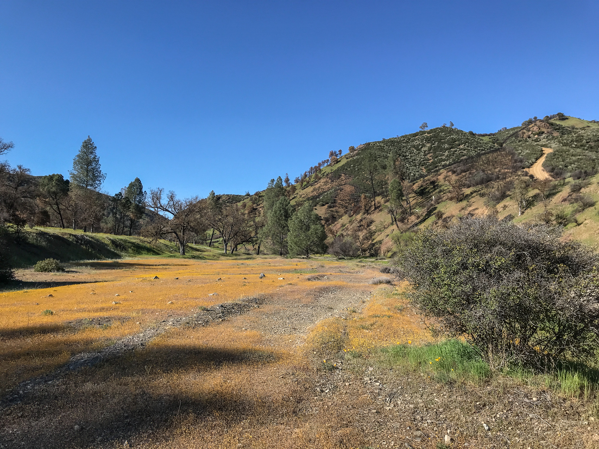
On the April Save Mount Diablo tour, fields of green grasses and wildflowers were rising from the ashes all around. At one of our first stops, near where creeks come together at Los Cruzeros, the poppies and popcorn flowers were so prolific that we asked if we were still in the burn. We were, park staff assured us. The park was restoring itself, better than ever.
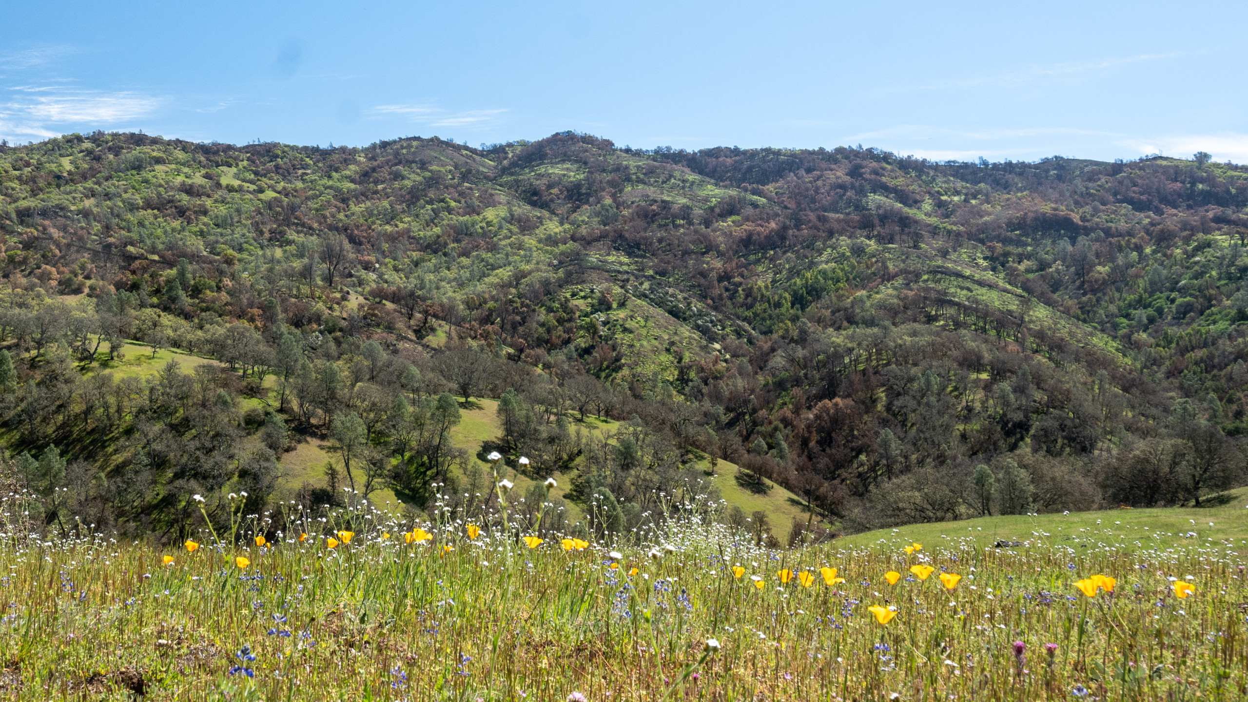
A lush recovery at Henry Coe with poppies, popcorn flowers, and more
In his written report on the fire, Gray explained, “There was a lot of consumption of downed trees and other fuel loads, while not burning so hot as to damage seed banks or consume old heritage trees. Many of the hillsides burned in a perfect mosaic pattern leaving green, unburnt vegetation. This will provide refuge for wildlife and lead to an increased diversity in plant age class over time.”
When two of us returned to the park for a backpack trip in May, we worried about what might have happened after a dry month. But the park was still full of life. Western toads, Pacific tree frogs, and Diablo Range garter snakes cavorted in the creeks; pond turtles were in the lakes, a horned lizard was in the chaparral; and, above it all, a golden eagle.
We gazed across steep canyons to see splashes of yellow daisy-family flowers covering large swaths of distant chaparral burns. Up close we found yellow mariposas, white star lilies, and velvety bush mallows popping up among the skeletal shrubs.
Creekside, a single white-fairy-lantern stalk supported a dozen delicate blossoms. The shores of Mississippi Lake were dotted with the red and purple of paintbrush and Collinsia. It was a weird wonderland: bare in places; lush in others; intriguing throughout.

Paintbrush and Collinsia near Mississippi Lake
Fire has long been part of the lives of the Amah Mutsun people, the first residents of the land that is now Henry W. Coe State Park. Before the European invasion, they welcomed fires, setting them intentionally to improve hunting success and rejuvenate food crops such as wild lettuce (aka miner’s lettuce), chia, acorns, and bulbs.
A thick stand of chamise chaparral is practically impenetrable to a hunter and has little to offer a forager. But, after a fire, open chaparral offers better access to game and a wide variety of edible plants. That era ended when the Spanish came in the late 1700s and forcibly removed native peoples from their lands.
For most of the 20th century, fires were suppressed, not welcomed. At Coe, a fire sprawled across most of the park in 1961. After that, nothing major hit until the Lick Fire of 2007 burned about two-thirds of the park—approximately the same area as the 2020 fire. The 13-year interval between Lick and the SCU fires didn’t allow much time for shrubs and trees to bounce back, but somehow they did.
Coe’s recovery from the Lick Fire was documented by Stanford plant biologist Dr. Winslow Briggs in his book, The Trails of Henry W. Coe State Park. A volunteer at Coe for 40 years, Briggs explained how fire aided the reproduction of some Coe shrubs. Buck brush, jim brush, deerweed, and chaparral whitethorn have seeds that require a heat shock to break their water-impervious seed coat and initiate germination.
But the temperature of the heat shock needs to be near the boiling point of water: 212 degrees F. If the temperature reaches 30 to 40 degrees more than 212, germination is reduced. If even higher, seeds are killed.
Briggs noted that species such as Eastwood manzanita and California sagebrush don’t respond to heat shock, but they do respond to the nitric oxide (NO2) in smoke.
Whispering bells, a plant that only appears after a fire, also requires nitric oxide to germinate. Its seeds can remain viable and dormant for more than 50 years waiting for exposure to smoke to cause them to germinate. Charred wood, which also contains nitric oxide, stimulates germination of additional species, including chamise, chaparral clematis, golden yarrow, and poison oak.
Coe has rare coastal stands of ponderosa pines along its western ridges. Before the fire, Gray feared that “ladder fuels” near the ground could put those pines at risk in a major wildfire. He deployed California Conservation Corps crews to clear out manzanita and other shrubs so that a prescribed burn could be set to create a more fire-resistant forest.

Clearing shrubs to prevent catastrophic fire at Manzanita Point
But before Gray could carry out the prescribed burn, the SCU fire hit. Fire crews cleared brush and set low-intensity backfires that protected the pines on Blue Ridge. And, to Gray’s relief, the SCU fire never reached the ponderosa pines on Pine and Middle ridges.
Prior to the SCU fire, thick stands of cattails and rushes were blocking access to some of the reservoirs in Coe’s backcountry. So Gray lowered water levels in Coit and Kelly lakes to dry out vegetation in preparation for a prescribed burn.
Again, the SCU fire finished the job for him. At Mississippi Lake, however, where the water level had not been lowered, the cattails and rushes were too moist to burn.
“We’re trying to get into more prescribed burning,” Gray said on a park tour in April 2021. “But it takes years of planning and a lot of money and effort to do even a thousand acres. So really the only way to have an effective fire regime is to have a big wildfire come through in a park like this.”
Kelly Lake after the burn
While encouraging low-intensity fires in the backcountry, Gray wants to avoid an event like the Cedar Fire, which hit Cuyamaca Rancho State Park near San Diego in 2003. Started by a lost hiker, that conflagration killed 14 people and destroyed 2,232 homes, 566 outbuildings, and 22 commercial properties. The huge, hot fire incinerated almost all of the 25,000-acre state park, including its signature pines.
After monitoring sparse pine recovery for four years, Cuyamaca managers decided to re-plant its forests, at great expense, with 350,000 pine, cedar, and fir seedlings. “The fire didn’t leave patches of refuge that would have allowed the forest to propagate and grow again,” said park restoration manager Lisa Gonzalez-Kramer.
So Cedar was a notoriously bad fire. The SCU fire at Coe is being celebrated as a good one. Yet fire itself is non-binary, neither bad nor good, but a more nuanced force with varying effects on humans and ecosystems. Those effects are influenced by the frequency, intensity, and location of fires, as well as complex factors like drought, heat, and even livestock grazing.
Goldfields growing alongside a creek bed
One thing is certain, though. Wildfires are much easier to live with and appreciate when they occur in mostly unoccupied landscapes—places where fires can be allowed to burn, places where land managers can get help from nature to reduce fuel loads that endanger communities.
Fortunately, the Diablo Range is mostly undeveloped—a place where fire can do its rejuvenating work if humans let it. Seventy-five percent of the ecologically important area around Mount Diablo has been preserved. But in the whole 150-mile-long range, only about a quarter of the land is protected.
Easements and land held by The Nature Conservancy, the University of California, and Santa Clara Valley Open Space Authority provide buffers and keep some additional land on the west side of the range safe.
But on the east side of the Diablo Range, developers are busy. The Diablo Grande subdivision at the mouth of Del Puerto Canyon near Patterson juts deep into fire-prone areas, with expansions planned. A Tracy Hills subdivision is rising up on both sides of I-580 near Tracy.
If developments like these proliferate without buffering grassland preserves like the ones on the west side, the next big wildfire in the Diablo Range could be a far different story.
Pine Ridge in Henry Coe

