What the New Wildfire Hazard Maps Mean and What You Can Do
The California Department of Forestry and Fire Prevention (CAL FIRE) recently released new Fire Hazard Severity Zone (FHSZ) maps for Contra Costa County, including for the cities of Concord, Antioch, and Pittsburg.
Old maps from 2011 showed only areas deemed “very high” hazard. The new ones also show that category but adds areas with “high” and “moderate” hazard.
What’s the Takeaway for Concord?
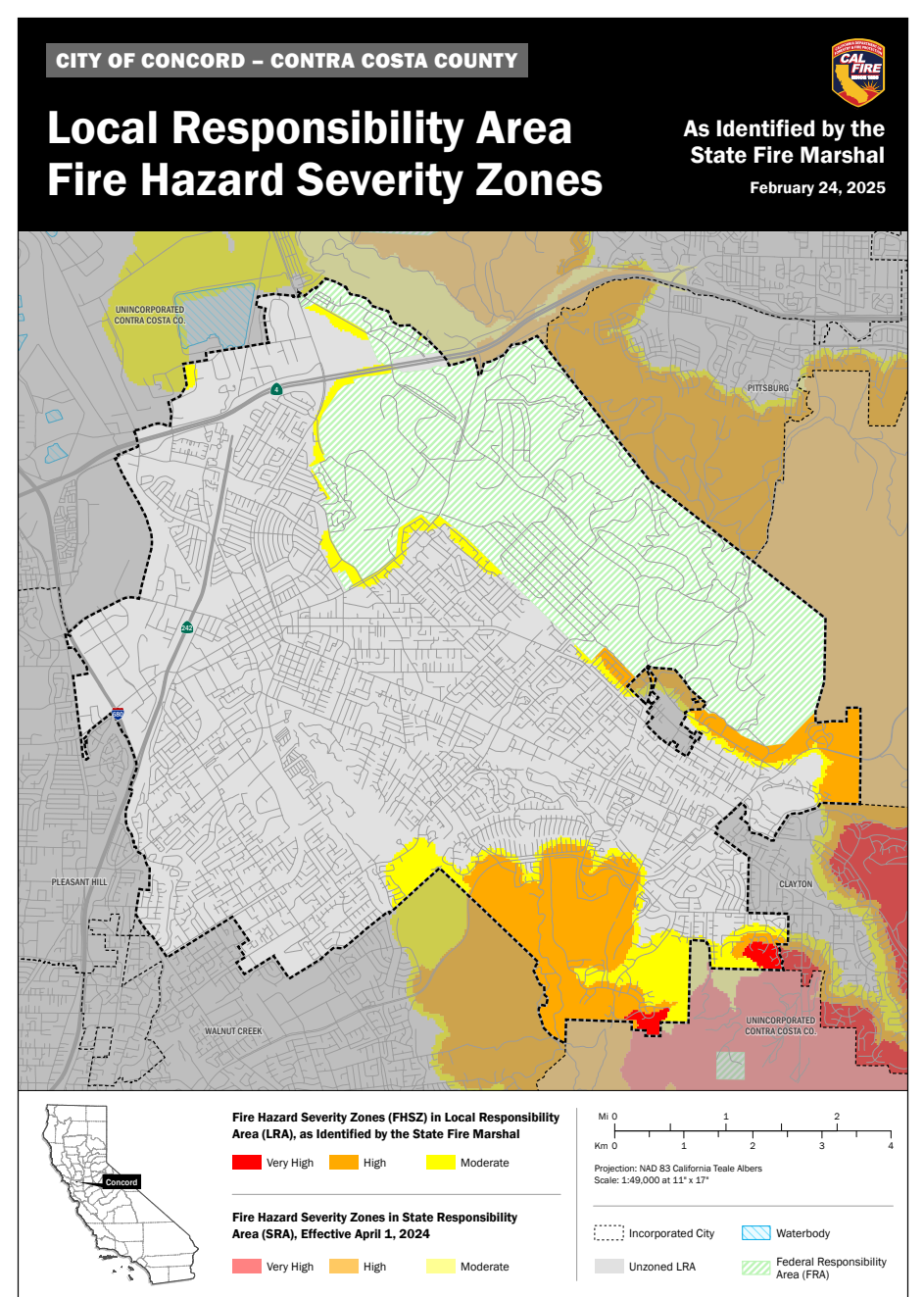
Neighborhoods around, and especially south of, Ygnacio Valley Road in the area of the Cal State East Bay Concord Campus, especially the Crystyl Ranch neighborhood, and pockets in the southeast corner of the city, have “high” and sometimes “very high” fire hazard conditions.
A band of development along the southeast corner of the new Thurgood Marshall Regional Park also has high fire hazard conditions.
Visit the City of Concord’s web page on fire severity zones for more information.
What’s the Takeaway for Antioch?
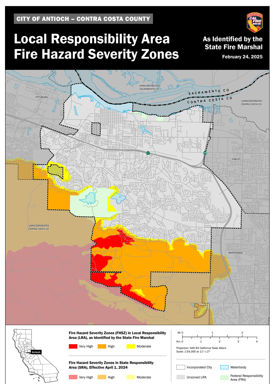
Neighborhoods all along the southern and southwestern borders of Antioch have high fire hazard conditions. High fire hazard zones include almost the entire Sand Creek area, parts of which are undergoing development.
Large parts of southwest Antioch that are undeveloped face very high fire hazard. The Zeka property, which is surrounded on three sides by protected lands and should added to these protected habitats, is in a very high fire hazard zone.
Even some existing neighborhoods face very high fire hazard in Antioch, including those along Southwood Way.
What’s the Takeaway for Pittsburg?
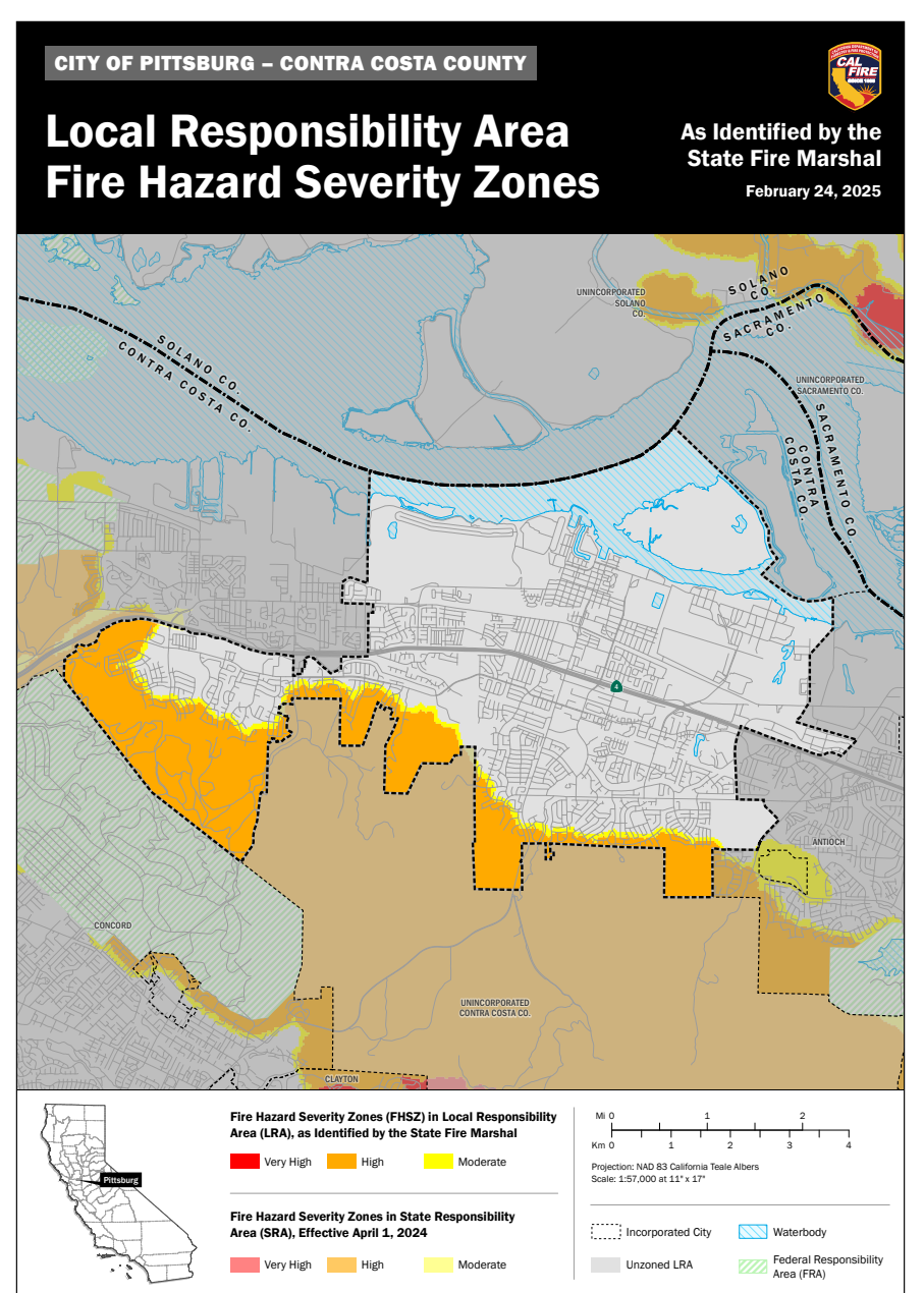
Neighborhoods all along the southern border of Pittsburg and the westernmost part of the city have “high” fire hazard conditions.
High fire hazard zones include the entire area in Pittsburg’s southwest hills that the Faria project would be built on.
The Faria project has been proposed by Seeno company developers and approved twice by the Pittsburg City Council, despite opposition from Save Mount Diablo, other community groups, and many Pittsburg residents.
Going Deeper with These New Wildfire Hazard Assessments
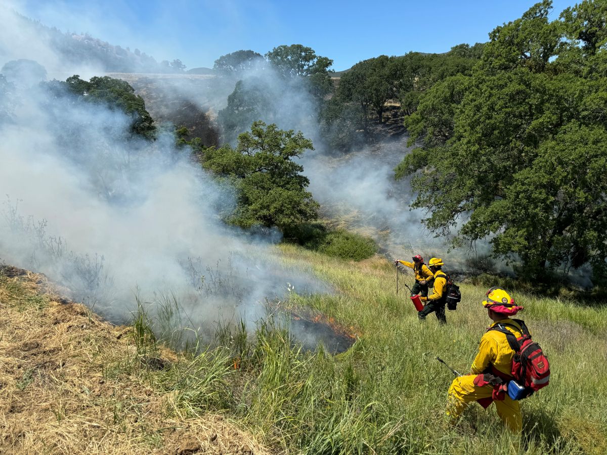
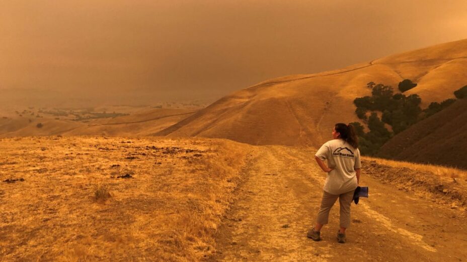
California State Park fire staff lighting an ecological burn at Mount Diablo State Park in Clayton last year. This fire was supported by Save Mount Diablo, and is an example of ecological burning that improves habitat for native wildlife, reduces the risk of catastrophic wildlife, and helps protect human communities by reducing potential fuel near development. Photo by Haley Sutton
To see the new maps for Contra Costa and all cities in the county, visit the CAL FIRE website. Also, check out CAL FIRE’s interactive slidable “before and after” map of Local Response Area old and new zones that illustrates how things have changed.
These maps are intended to show hazard, not risk. They show the probability that an area will burn, not the damage a fire would cause.
The hazard assessment is based on physical conditions that create the likelihood of fire and expected fire behavior over a 30- to 50-year period without considering mitigation measures such as home hardening, recent wildfire, or fuel reduction efforts.
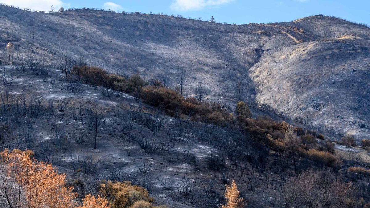
Aftermath of the 2020 SCU Lightning Complex fires, which spread across 625 square miles of the Diablo Range in six California counties. Photo by Bruce and Joan Hamilton
To determine the hazard level for an area, factors such as fire history, existing and potential vegetation, predicted flame length, ember-dispersion distances, terrain, and weather patterns are included.
Homeowners who live in areas now deemed at very high hazard on the maps will have to comply with the Zone 0 regulation expected to take effect at the start of next year, mandating a five-foot zone around every house free of flammable materials vulnerable to flying embers.
Some CAL FIRE officials have pointed out that the maps could give residents in areas considered moderate or no hazard a false sense of security.
The maps do not consider structures including homes and other buildings as “fuel” that can contribute to rapid fire spread, as happened in the catastrophic Los Angeles fires. Some officials would like to see the Zone 0 regulation apply to all the hazard zones.
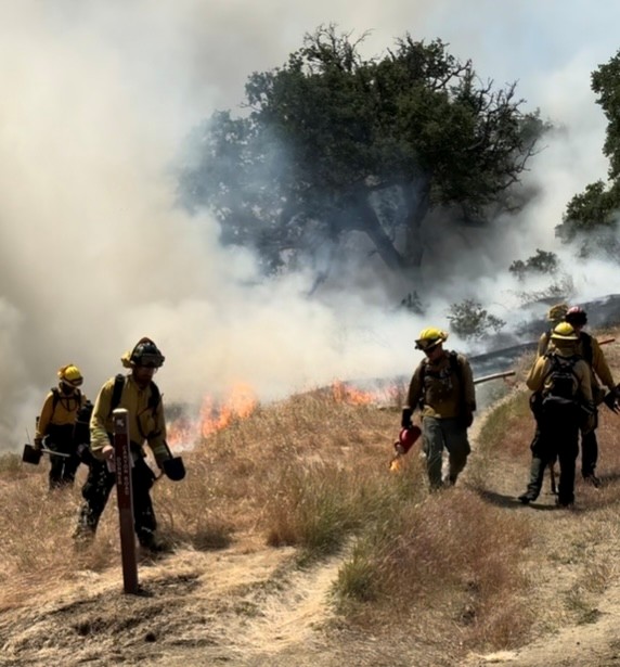
California State Park fire staff lighting an ecological burn at Mount Diablo State Park in Clayton last year. This fire was supported by Save Mount Diablo, and is an example of ecological burning that improves habitat for native wildlife, reduces the risk of catastrophic wildlife, and helps protect human communities by reducing potential fuel near development. Photo by Juan Pablo Galván Martínez
Climate change caused by human activities emitting carbon pollution into the atmosphere is a key factor in making wildfire in California more frequent, more intense, and larger.
Bad land use practices, such as expanding development into open space around cities, rather than building up in already developed areas, increase the risk that catastrophic wildfire will take an increasing toll on human lives and property.
Save Mount Diablo works to solve the overlapping and interconnected causes of the fire emergency we face by
- confronting the climate crisis with the seriousness and urgency that it demands,
- advocating for good land use policy that protects open space,
- fighting bad developments that put our neighborhoods at risk through more sprawl, and
- supporting ecological and cultural burning practices.
To learn more about the root issues causing our fire emergency and how to solve them, see the additional resources at the end of this blog post.
You can also help by joining Save Mount Diablo and talking to your local decision makers about
- protecting wildlife and open space,
- building up rather than out,
- increasing protected lands to buffer human communities, and
- creating and implementing good land use policies to make healthier, more sustainable communities.
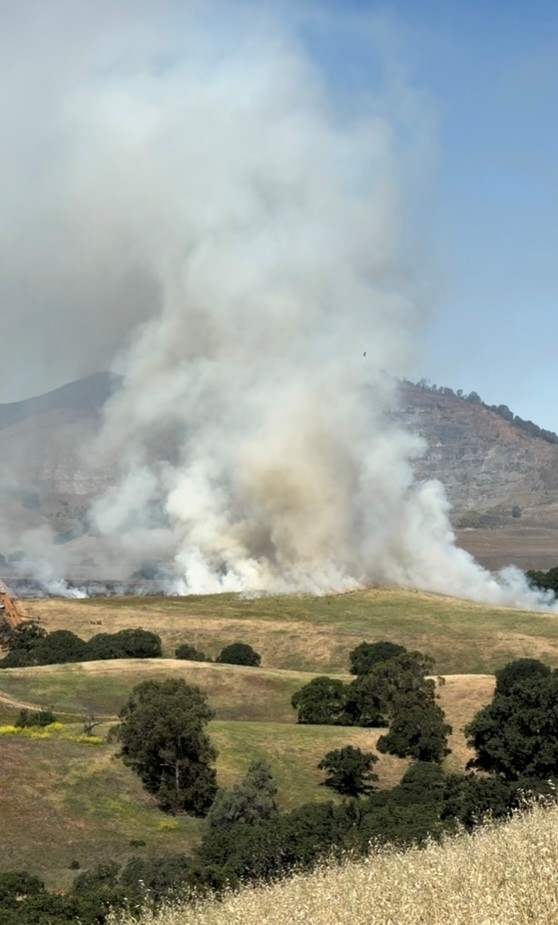
Ecological burn at Mount Diablo State Park in Clayton last year. This fire was supported by Save Mount Diablo, and is an example of ecological burning that improves habitat for native wildlife, reduces the risk of catastrophic wildlife, and helps protect human communities by reducing potential fuel near development. Photo by Juan Pablo Galván Martínez
CAL FIRE is a state agency responsible for protecting natural resources from fire on land designated by the State Board of Forestry as a State Responsibility Area (SRA). To better prepare, CAL FIRE classifies the severity of fire hazard in areas of California.
Updated maps released in February and March classified hazard areas that local agencies are responsible for, not CAL FIRE, though CAL FIRE may still assist with fires in these Local Responsibility Areas (LRAs).
The fire agency responsible for most of the LRAs in Contra Costa County is the Contra Costa Fire Protection District (CON FIRE). CON FIRE has until June 24, 2025, to adopt the new maps that include Concord, Antioch, and Pittsburg.
Additional Resources: Root Issues Causing Our Fire Emergency and How to Solve Them
- How Do We Solve the Wicked Problem? The State of Fire Science in California (Video with Professor Michael Gollner, UC Berkeley, California Fire Science Seminar Series)
- California Burning—The Climate Crisis Is Setting the State on Fire (Article series from ProPublica)
- Why Wildfires Have Gotten Worse—and What We Can Do about It (TED talk by Dr. Paul Hessburg, USDA Forest Service)
- FUSEE Commends Report, Calls for Paradigm Shift from Firefighting to Firelighting (Article)
- Suppressing Fires Has Failed. Here’s What California Needs to Do Instead (Article by James Temple, MIT Technology Review)
- The Role of Climate Change in the Catastrophic 2025 Los Angeles Fires (Article by Jeff Masters and Bob Henson, Yale Climate Connections)
- ‘A New Wildfire Paradigm’: Why California Fires Are Growing Larger and More Destructive (Article by Dinah Voyles Pulver, USA Today)
- Climate Change, Not Endangered Species Protection, Is a Big Culprit in Los Angeles Fires (Article by Johani Carolina Ponce, Yale Climate Connections)
- The Many Ways Climate Change Worsens California Wildfires (Article by Dana Nuccitelli, Yale Climate Connections)

